Read on for two project updates from the Centre for Mined Land Rehabilitation (CMLR) of the Sustainable Minerals Institute (UQ).
High-res, 3D environmental drone-mapping Hercules legacy waste and
Isolated and incredibly steep, the former Hercules mine on the side of Mt Read in western Tasmania is getting a helping hand from drone technology.
Mine dumps of the 1890s are a far cry from tailings dumps of now – 100 years of mine waste was simply dropped off the side of Mt Read, leading to oxidising waste rock in creeks and creating acid mine drainage (AMD) spots.
Professor Peter Erskine (Director of CMLR) and Associate Professor Steven Micklethwaite (BRC) are working on drone solutions that can much more quickly map and monitor environmental hazards and health – especially with high resolution and more coverage.
“The miners of the day built lots of holes, and the holes now allow water into them [causing AMD] – and no one mapped those holes. MMG is trying to work out how to solve those legacy issues,” says Dr Erskine.
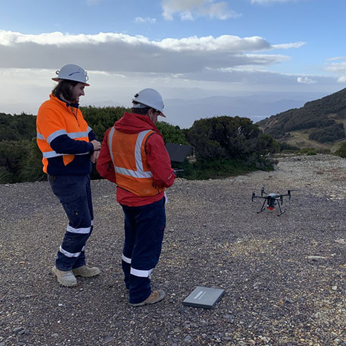
Data from drones, combined with high-quality mineralogical and geochemical information, is on the way to providing 3D information about plant health, high-risk spots for erosion, and likely source places for AMD.
Further than gathering data, Dr Erskine may assist with management decisions about how companies might solve those rehabilitation problems, develop experiments that address stabilising the very steep site to do so, and oversee how it is set up for success.
Checking long-term rehabilitation outcomes with NT Traditional Owners
The closed Nabarlek Uranium Mine (Alligator Rivers region, Northern Territory) is a unique opportunity for Traditional Owners (TOs) and researchers in Australia.
One of the first Australian mines to undertake a formal rehabilitation process, it is a chance to learn what a 25-year rehabilitated mine looks and how it functions, and integrate these ideas with TOs’ needs.
Dr Erskine and PhD candidate Kate Harries have been capturing detailed data about rehabilitation with the Supervising Scientist Branch of the Australian Government (Department of Climate Change, Energy, the Environment and Water) using drones, and traditional surveys of plants, animals and soils. Surveys are helping to interpret what ‘success’ means for long-term rehabilitation trajectories.
“For instance, looking at weed or tree species that people want on the land: can our drones distinguish between particular eucalyptus species or an Acacia species?” Dr Erskine explains.
Ms Harries has completed a meta-analysis of restored sites from around the world, to create a framework of measures and patterns over time in how different things have been restored.
There is an assumption, Ms Harries says, that “if you give things enough time, things will sort themselves out”, but that is not the case for mined land rehabilitation.
She also highlights that simple environmental indictors are insufficient. “People look at soil carbon, that may start off with a low value because crushed rock has very little carbon. And then later, perhaps there are invasive grasses that have grown, with massive amounts of carbon there. But that’s not a value that’s meaningful or landscape that’s necessarily functioning as before.”
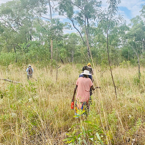
Ms Harries recently worked with TOs to find sites that reflect a functioning, healthy ecosystem (‘reference sites’): “We walked with an elderly lady who knows what it was like there before. It was fascinating having her talk about the site, and confirming a good reference site – which is a great outcome for consultation.
“She said, ‘You know, I want to see the right trees in the right place, I want to see them flowering at the right time, fruiting at the right time, the animals coming in, the birds coming in.’ TOs want to see a functioning native ecosystem, which is actually quite similar to what the scientists who are using ecosystem science perspectives are looking at.”
The site also has to be walkable (called a traversable natural walking surface) – and these are the kinds of insights crucial for other projects such as planning the closure of the Ranger Mine.
“The site has to return to the people, and they have to be confident that it's safe and sustainable,” Ms Harries says.
Next steps include to work out how TOs can take over monitoring these sites, and own that information themselves.
For more information:
Professor Peter Erskine
Director, Centre for Mined Land Rehabilitation, Sustainable Minerals Institute
Email: p.erskine@uq.edu.au
Kate Harries
PhD Candidate, Centre for Mined Land Rehabilitation, Sustainable Minerals Institute
Email: k.harries@uq.edu.au
 were part of the European-led m4mining consortium that delivered a hyperspectral imaging system capable of mapping surface patterns of minerals, soils, and plants from the air in real time, aiding exploration and mining activities.")
")
