 Roughly 600,000 sq km of Queensland’s deep crust has been modelled as part of a collaborative project that aims to equip the state’s resource explorers with information to help focus their efforts.
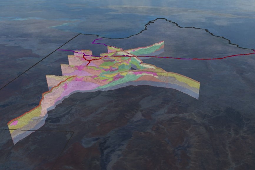
W.H. Bryan Mining and Geology Research Centre (BRC) Principal Research Fellow Associate Professor Karen Connors teamed up with Geological Survey of Queensland (GSQ) geoscientists Dominic Brown and Janelle Simpson to produce the new interpretation of the 2974 line kilometre of deep crustal seismic data, which stretches from Birdsville to Camooweal and across to Georgetown.
The project was accomplished through integrated interpretation of the seismic data with a wide range of geological datasets, and supported by geophysical modelling. Additional isotopic dating was provided by Geoscience Australia.
“The work involved going along the top of each seismic line and detailing all the outcrop geology, where the major structures are, and integrating data from a variety of sources that are all in their own format,” Associate Professor Connors said.
Ultimately, the team aimed to increase the understanding of the controls on mineralisation in Queensland, and therefore support the efforts of explorers in the state.
“There are a number of deep crustal seismic lines that image the entire thickness of the crust, down to roughly 50–60km depth, and while many of these lines had some interpretation, there hasn’t been a consistent, regional interpretation including all of these lines,” Associate Professor Connors said.
“The key is getting a consistent interpretation across the seismic lines so that we understand the crustal architecture and location of the major faults, that may have acted as fluid conduits during mineralisation.
“These fluids conduits concentrate the metal-bearing fluids during transport through the crust and thereby provide a guide on where to explore for the zones in which the metal ‘dropped out’ to form a deposit.”
The results of the project have been published and are now publicly available on the Geological Survey of Queensland website.
“A lot of the companies actually exploring in Queensland are juniors, and many just don’t have the staff, money or regional expertise to do this sort of work,” Associate Professor Connors said.
“Providing a model of the crustal architecture on a regional scale, as we have in this project, can help a company with limited resources understand the region geology better and improve their chances of discovering mineralised areas.
“Companies are already using the interpretation as a first-pass assessment on what geology to expect at surface and at greater depth – it gives them more confidence to proceed.
“The feedback has all been very positive.”
The BRC-GSQ team is now collaborating on a project that aims to update the seismic interpretation of an area in North-West Queensland, which can be read about here.
 were part of the European-led m4mining consortium that delivered a hyperspectral imaging system capable of mapping surface patterns of minerals, soils, and plants from the air in real time, aiding exploration and mining activities.")
")
